Springtime at Mars’ south pole
ESA’s Mars Express celebrates eight years in space with a new view of ice in the southern polar region of Mars. The poles are closely linked to the planet’s climate and constantly change with the seasons. Their study is an important scientific objective of the mission.
A wider contextual image showing the region around Ulyxis Rupes, in the southern polar region of Mars.

About two-thirds of the image is covered by part of the southern polar ice cap and other scattered ice deposits, near a feature known as Ulyxis Rupes. The left side of the image is dominated by the polar cap’s ice shield, which is covered by dark dusty material that hides the bright ices beneath.
At this location, further than 1000 km from the south pole itself, the ice is relatively thin: radar data indicate it is only about 500 m thick, whereas near the south pole it can reach more than 3.7 km.
Ulyxis Rupes is a large cliff, just visible in the image as indicated here by arrows. South is to the left, north is to the right. North-facing cliffs show layers of ice and dust, known as polar layered deposits (box 1). About halfway across the image, there are large ice deposits that are heavily covered (box 2). The overlying material has been blown into long dunes by the prevailing winds in this region. With increasing distance from the south pole, the ice becomes confined to larger impact craters (box 3). Puzzling parallel structures in the martian dust can also be seen (boxes 4 and 5). Although the origin of these features is uncertain, it is possible that they are the result of underlying ice deposits.

Credits: ESA/DLR/FU Berlin (G. Neukum)
However, on the north-facing cliffs the layers of ice and dust are discernible. These form part of the polar, layered deposits. The cliffs are often curved, which could mean that they are shaped by underlying impact craters.
The elevation of this region decreases markedly from south to north, dropping in steps by about 1500 m in total from left to right across the image.
The elevation of this region decreases markedly from south to north, dropping in steps by about 1500 m in total from left to right across the image. The image was created using a Digital Terrain Model (DTM) obtained from the High Resolution Stereo Camera on ESA’s Mars Express spacecraft. Elevation data from the DTM is colour coded: purple indicates the lowest lying regions and grey the highest.

Credits: ESA/DLR/FU Berlin (G. Neukum)
Just northward of the ice shield, about halfway across the image, there are large ice deposits that are heavily covered by overlying material blown into long dunes by the prevailing winds in this region. The orientation of the dunes suggests the wind must come predominantly from the northwest.
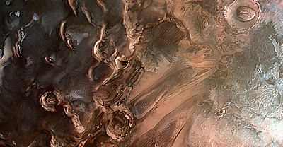
Buried ice deposits in the southern polar region of Mars are shown in this image, close to Ulyxis Rupes at about 72°S/162°E. The image was obtained by Mars Express on 15 January 2011 during orbit 8995 using the High Resolution Stereo Camera and has a ground resolution of about 49 m per pixel. It was derived from the nadir channel, which provides the highest detail of all the channels. South is to the left, north is to the right.

Credits: ESA/DLR/FU Berlin (G. Neukum)
With increasing distance from the south pole, ice becomes confined to larger impact craters, such as the one in the top right of the image. These provide the best shelter. The ice itself is slightly offset towards the north because, with the sunlight coming from the north, the southern walls of the crater tend to warm up more, causing the ice to melt.
Ulyxis Rupes is a large cliff and is the only named feature in this image (‘rupes’ is the Latin term for cliff). With a length of 390 km and a height of up to 1 km, it is just visible at the top right of this image where it intrudes on the immediate left of the crater there.
The layers in these cliffs show buried ice deposits in the southern polar region of Mars close to Ulyxis Rupes at about 72°S/162°E. The image was obtained by Mars Express on 15 January 2011 during orbit 8995 using the High Resolution Stereo Camera. These perspective views have been calculated from the Digital Terrain Model derived from the stereo channels.

Credits: ESA/DLR/FU Berlin (G. Neukum)
Buried ice deposits in the southern polar region of Mars are shown in this image, close to Ulyxis Rupes at about 72°S/162°E. The image was obtained by Mars Express on 15 January 2011 during orbit 8995 using the High Resolution Stereo Camera and has a ground resolution of about 49 m per pixel. It was derived from the nadir channel, which provides the highest detail of all the channels. South is to the left, north is to the right.
Credits: ESA/DLR/FU Berlin (G. Neukum)
With increasing distance from the south pole, ice becomes confined to larger impact craters, such as the one in the top right of the image. These provide the best shelter. The ice itself is slightly offset towards the north because, with the sunlight coming from the north, the southern walls of the crater tend to warm up more, causing the ice to melt.
Ulyxis Rupes is a large cliff and is the only named feature in this image (‘rupes’ is the Latin term for cliff). With a length of 390 km and a height of up to 1 km, it is just visible at the top right of this image where it intrudes on the immediate left of the crater there.
The layers in these cliffs show buried ice deposits in the southern polar region of Mars close to Ulyxis Rupes at about 72°S/162°E. The image was obtained by Mars Express on 15 January 2011 during orbit 8995 using the High Resolution Stereo Camera. These perspective views have been calculated from the Digital Terrain Model derived from the stereo channels.
Credits: ESA/DLR/FU Berlin (G. Neukum)
Puzzling parallel structures in the martian dust can be seen in the bottom right quarter of the image. Although their origin is uncertain, it is possible that they are the result of underlying ice deposits, permanently frozen because they are protected by overlying dust and rocks.
The image was taken in January 2011, during the southern spring on Mars. At the moment it is summer there, but when the southern winter begins in March 2012, the temperatures will drop again and more ice will accumulate. Mars Express will be waiting.
Buried ice deposits in the southern polar region of Mars close to Ulyxis Rupes at about 72°S/162°E. The elevation of this region decreases markedly from south to north, dropping in steps by about 1500 m in total from left to right across the image. The High Resolution Stereo Camera (HRSC) on ESA’s Mars Express took this image. It combines data from HRSC’s nadir channel and one stereo channel to produce this 3D image. Stereoscopic glasses are required to see the 3D effect. Credits: ESA/DLR/FU Berlin (G. Neukum) |
Source: ESA
0 comments:
Post a Comment