Discover ESA’s ice mission, track it in real time and obtain the latest measurements with the new CryoSat application. CryoSat is measuring the thickness of polar sea ice and monitoring changes in the ice sheets that blanket Greenland and Antarctica.
The CryoSat iPhone and iPad application – or CryoSatApp – is now available at Apple's App Store.
CryoSatApp’s main menu provides access to four sections: mission description, a 3D model of the satellite, position tracking and data visualization.

Information on CryoSat’s current position is automatically updated, including its visibility over selected ground stations. Users can also track the satellite’s position in relation to the iPhone or iPad’s geographical location.
 Credits: ACS/ESA
In the first section, users can easily find information on the CryoSat mission, including images, videos, archived news and an overview of how CryoSat obtains and delivers data.
The 3D model feature allows users to zoom in on how the satellite is built and discover its instruments – such as the radar altimeter for measuring ice thickness.
Information on CryoSat’s current position is automatically updated, including its visibility over selected ground stations. Users can also track the satellite’s position in relation to the iPhone or iPad’s geographical location.
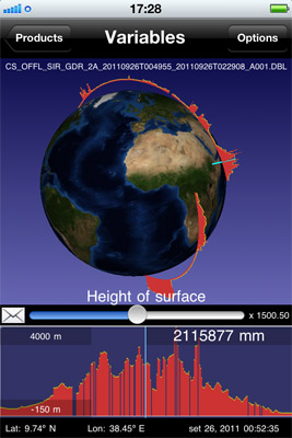
With the new CryoSatApp, elevation profiles are at your fingertips. Users can select the day and orbit from which they want to extract the data, and view Earth’s ice profile from that orbit.
 Credits: ACS/ESA
Surface elevation
But it’s the data feature that makes this app unique. Not only does it give access to all of CryoSat’s measurements, it can help you visualise the ice sheets by providing a vertical profile over the area.
All geophysical parameters stored in the CryoSat products can be easily displayed at the touch of your fingertips as soon as they are generated on the ground. Users can select the day and orbit from which they want to extract the data, and view Earth’s ice profile from that orbit.
This is a remarkable tool for students and scientists engaged in using CryoSat products.
The CryoSatApp offers a 3D model of the satellite, allowing users to discover the instruments.
 Credits: ACS/ESA
Since its launch in April 2010, CryoSat-2 has been collecting data to improve our understanding of the relationship between ice and climate.
In June 2011, the first map of Arctic sea-ice thickness was unveiled. The satellite will continue to monitor the changing ice for years to come.
Contacts and sources:
The CryoSat iPhone and iPad application – or CryoSatApp – is now available at Apple's App Store.
CryoSatApp’s main menu provides access to four sections: mission description, a 3D model of the satellite, position tracking and data visualization.
Information on CryoSat’s current position is automatically updated, including its visibility over selected ground stations. Users can also track the satellite’s position in relation to the iPhone or iPad’s geographical location.
In the first section, users can easily find information on the CryoSat mission, including images, videos, archived news and an overview of how CryoSat obtains and delivers data.
The 3D model feature allows users to zoom in on how the satellite is built and discover its instruments – such as the radar altimeter for measuring ice thickness.
Information on CryoSat’s current position is automatically updated, including its visibility over selected ground stations. Users can also track the satellite’s position in relation to the iPhone or iPad’s geographical location.
With the new CryoSatApp, elevation profiles are at your fingertips. Users can select the day and orbit from which they want to extract the data, and view Earth’s ice profile from that orbit.
But it’s the data feature that makes this app unique. Not only does it give access to all of CryoSat’s measurements, it can help you visualise the ice sheets by providing a vertical profile over the area.
All geophysical parameters stored in the CryoSat products can be easily displayed at the touch of your fingertips as soon as they are generated on the ground. Users can select the day and orbit from which they want to extract the data, and view Earth’s ice profile from that orbit.
This is a remarkable tool for students and scientists engaged in using CryoSat products.
The CryoSatApp offers a 3D model of the satellite, allowing users to discover the instruments.
Since its launch in April 2010, CryoSat-2 has been collecting data to improve our understanding of the relationship between ice and climate.
In June 2011, the first map of Arctic sea-ice thickness was unveiled. The satellite will continue to monitor the changing ice for years to come.
Contacts and sources:
ESA
0 comments:
Post a Comment